Take a 3D plunge into 19th-century Geneva

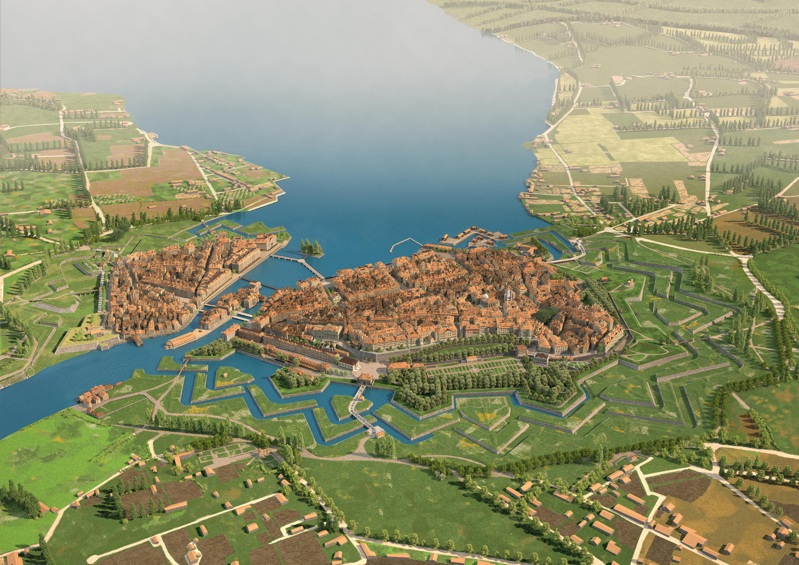
You can now travel back in time to 1850 and walk the cobbled streets of Geneva and its imposing mediaeval defences thanks to a new online cityscape. Future educational applications are planned using the 3D model’s open source data.
Officially launched on Tuesday, the immersive Google Street View-style mapExternal link of 19th-century Geneva was created by around 100 people over the past five years. It was built based on historic documents, and high-resolution images and scans of a huge 3D tin and copper model of Geneva in 1850External link, made by a team of artisans led by local architect Auguste Magnin (1841-1903).
Like Magnin’s model, the new free online version offers an immersive view of the city prior to the demolition of its fortifications in 1850 and subsequent changes to its architecture and population.
Geneva remained a fortified city much later than many other European cities. It was the so-called Fazy revolution of the mid-19th-century that led to the destruction of the ramparts and transformation of the city into residential districts, and the addition of public buildings, squares, streets and boulevards, churches, bridges and a railway and tram network. Geneva’s famous lake fountain was inaugurated in 1891.
The opening-up of the historic city and resulting construction work led to a social transformation. The city population doubled between 1843 and 1910 from 29,289 to 58,337, thanks to an influx of foreign workers mostly from France.
“This period really was a revolution for Geneva,” said project leader Thierry Sangouard. “It also represented a change in people’s way of thinking. These fortifications maintained a certain state of mind. The wealthy people who owned the land and buildings were scared they might lose value and tens of hectares might be built upon.”
While there are no humans visible in the online version, the digital engineers have recreated 2,000 buildings and 1,333 roads and paths, ramparts and lakeshore, respecting the dimensions, textures, colours and vegetation, based on historic documents.
Open source
The project was completed thanks to the financial support of a private foundation and in close collaboration with the local authorities, who have released the code as open source.
Various universities and researchers are interested in the initiative and plan to incorporate it in future projects.
The open source data is being integrated into the server of the Venice Time Machine digital projectExternal link at Lausanne’s Federal Institute of Technology (EPFL). There, research teams led by professor Frédéric Kaplan are scanning and digitising maps, documents, manuscripts and other records to create dynamic visual online platforms of cities that will allow scholars and the public to search and cross-reference historic information.
As well as Venice, and now Geneva, EPFL and other institutions are already working on similar ‘time machines’ of historic cities and centres of culture and commerce, including Paris, Amsterdam, Budapest and Jerusalem. These will show in detail how social networks, trade and knowledge have built up over centuries across Europe.
The University of Geneva is also using the new 3D model to teach students about historical migration issues.
“This model offers huge potential,” said University of Geneva assistant professor Adrien RemundExternal link. “It’s a collaborative tool that researchers and other people with historic information about the city can add online via the wiki.”
The Artamim Foundation, in collaboration with the city of Geneva, is also planning to develop VR-style headsets which will offer an immersive step back in time to 1850.

In compliance with the JTI standards
More: SWI swissinfo.ch certified by the Journalism Trust Initiative







You can find an overview of ongoing debates with our journalists here . Please join us!
If you want to start a conversation about a topic raised in this article or want to report factual errors, email us at english@swissinfo.ch.